Modern Geological Mapping of Taiwan
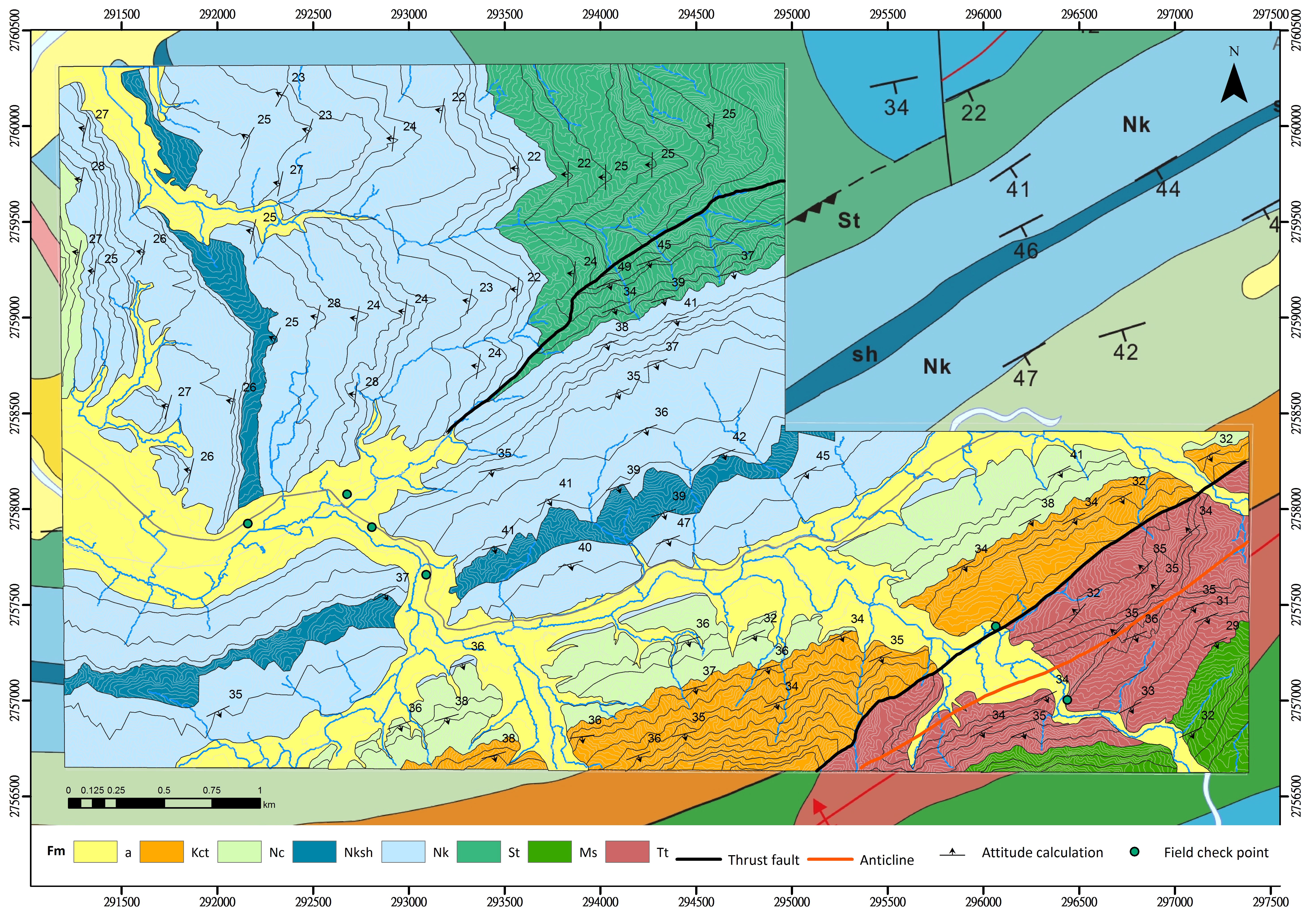
Table of Contents
- Modern Geological Mapping Background and Significance
- LiDAR and High-Resolution Topography for 3D Geological Mapping: Introduction to Related M.Sc. Theses (2018–2026)
- Wan-Ting Wei, 2026, #Western Foothills (Taoyuan)
- Yun-Pin Chen, 2025, #Southern Slate Belt and Tananao Schist
- Yu-Cheng Hsu, 2024, #Nothern Coastal Range
- Ting-Yu Pai, 2023, #Southern Coastal Range
- Po-Lien Chao, 2021, #Middle Coastal Range (Yuli)
- Cheng-Wei Sun, 2019, #Hsuehshan Range (Toucheng)
- Nai-Cih Shih, 2018, #Western Foothills and Hsuehshan Range (Shuanghsi)
- Chia-Hung Chiu, 2018, #Western Foothills (Taipei)
- 新世代地質製圖背景與重要性
- 光達與高解析度數值地形在三維地質製圖上的應用——相關碩士論文(2018–2026)
Modern Geological Mapping Background and Significance
Geological mapping is one of the most fundamental parts of geological research. A geological map records the distribution of rock units, faults, folds, and other structures at the Earth’s surface and provides the basis for understanding regional geology, tectonic development, natural hazards, groundwater resources, and engineering conditions.
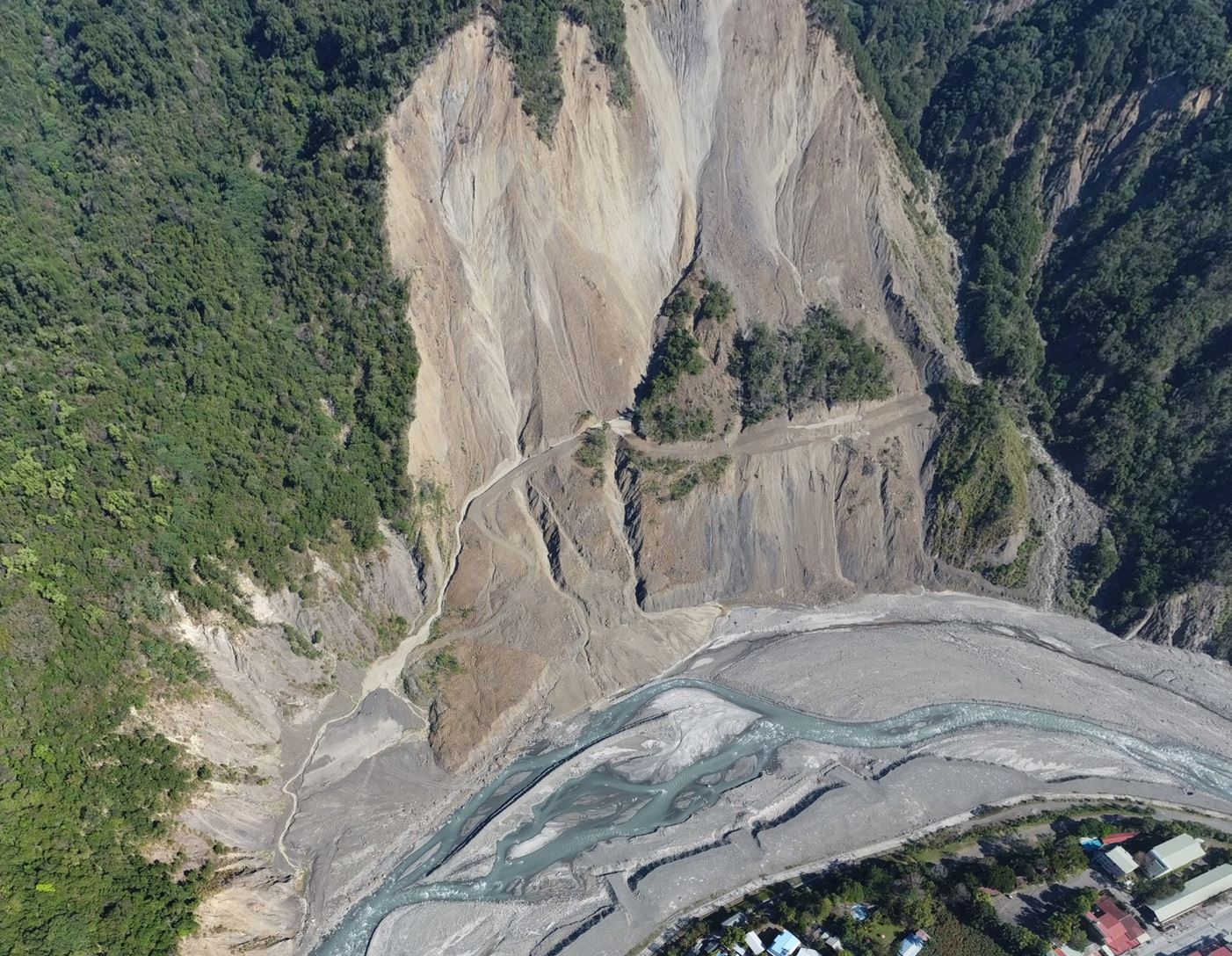
Traditional geological mapping relies mainly on field observations along roads, rivers, and accessible outcrops. In Taiwan, however, steep topography, dense vegetation, rapid erosion, and limited access frequently leave large areas without sufficient observations. These difficulties are particularly significant in mountainous regions, where important geological boundaries and structures may extend across terrain that cannot be examined directly in the field.
About fifteen years ago (year 2011), our research group began exploring how high-resolution digital elevation models, particularly airborne LiDAR-derived bare-earth topography, could be incorporated into geological mapping. LiDAR makes it possible to examine subtle landforms beneath forest cover and to recognize topographic patterns related to bedding, faults, folds, lithological boundaries, landslides, and other geological features.
Our approach does not replace conventional field geology. Instead, it combines several complementary sources of information:
- high-resolution LiDAR-derived digital elevation models;
- three-dimensional visualization and structural interpretation;
- aerial photographs and other remote-sensing data;
- UAV-based observation and photogrammetry;
- existing geological maps and published studies; and
- targeted field investigation for verification.
Working with my students, we gradually developed and tested this approach in several of Taiwan’s major geological terrains. The work began in the fold-and-thrust belt of the Western Foothills and was subsequently extended into the low-grade metamorphic rocks of the Hsuehshan Range, the volcanic and sedimentary terrains of the Coastal Range, and, more recently, the Slate Belt and Tananao Schist of the Central Range.
Each terrain presents different mapping problems. Bedding-related landforms are commonly recognizable in sedimentary rocks, whereas geological boundaries can be more difficult to identify in volcanic, highly deformed, or metamorphic rocks. The studies therefore required different combinations of topographic interpretation, structural analysis, three-dimensional mapping, UAV observation, and field verification.
A series of eight master’s theses has formed the foundation of this work. Together, these studies demonstrate how high-resolution topography can improve the precision and completeness of geological maps, particularly in areas where conventional field observations are sparse. They have also led to the recognition or reinterpretation of faults, folds, shear zones, stratigraphic boundaries, large landslides, and regional structural relationships.
This continuing project is not simply an effort to redraw existing geological maps at higher resolution. Its broader purpose is to develop a modern and reproducible framework for geological mapping in complex mountainous terrain. The resulting maps provide new information for tectonic research, slope-hazard assessment, engineering geology, and future field investigations.
The following pages introduce the individual mapping projects, their methods, principal findings, and contributions to understanding the geology of Taiwan.
LiDAR and High-Resolution Topography for 3D Geological Mapping: Introduction to Related M.Sc. Theses (2018–2026)
This series of studies uses high-resolution digital elevation models (DEMs), primarily derived from airborne LiDAR, together with three-dimensional terrain interpretation, field investigation, existing geological data, and structural analysis. The work has gradually established a modern geological mapping approach for areas of Taiwan where dense vegetation, steep terrain, limited exposure, and poor accessibility constrain conventional field mapping. The study areas extend from the Western Foothills and Hsuehshan Range to the Coastal Range and the slate belt of the Central Range. The research has also progressed from improving the locations of bedding traces, stratigraphic boundaries, and faults to analyzing fold geometry, foliation patterns, strain partitioning, and mountain-building processes. The following eight M.Sc. theses are listed from the most recent to the earliest.
Wan-Ting Wei, 2026, #Western Foothills (Taoyuan)
Degree and affiliation: M.Sc., Department of Earth Sciences, National Taiwan Normal University
Thesis title: Using 3D LiDAR Geological Mapping to Improve the Structural Geometry at the Boundary Between the Western Foothills and Hsuehshan Range: A Case Study of the Taoyuan Quadrangle
This study uses LiDAR-derived topography and 3D geological mapping to re-examine the boundary between the Western Foothills and the Hsuehshan Range in the Taoyuan Quadrangle. The Chuchih Fault has traditionally been regarded as the boundary between these two geological units, but stratigraphic ages and structural observations suggest that the relationship is more complicated. Bedding traces interpreted in a 3D GIS environment were used to refine the distributions and thicknesses of strata and the geometry of folds and faults. The location and displacement of the Chuchih Fault were also revised. The results show that the boundary is better understood as a broad structural zone involving several interacting folds and thrust faults rather than a single, clearly defined boundary fault.
Thesis link: https://doi.org/10.6345/NTNU202601070
Yun-Pin Chen, 2025, #Southern Slate Belt and Tananao Schist
Degree and affiliation: M.Sc., Department of Geosciences, National Taiwan University
Thesis title: LiDAR-Based 3D Foliation Mapping: Implications for Deformational Processes in the Southern Taiwan Orogen
This study extends LiDAR-based mapping from the conventional interpretation of bedding and faults to the regional mapping of foliation in the metamorphic terrain of the southern Central Range. LiDAR-derived structural lineaments were combined with field-based structural observations to distinguish bedding, metamorphic foliation, and different deformation patterns. This approach revealed previously unmapped macroscale structures and refined the three-dimensional distribution of foliation. The results indicate that forethrusting and left-lateral shearing dominate the southern Central Range, while backthrusting and extensional deformation occur locally. The spatial distribution and overprinting relationships of these structures record interactions among tectonic underplating, strain partitioning, and synorogenic extension. The study demonstrates that LiDAR mapping can improve structural investigations in poorly exposed and intensely deformed metamorphic terrains.
Thesis link: https://doi.org/10.6342/NTU202501805
Yu-Cheng Hsu, 2024, #Nothern Coastal Range
Degree and affiliation: M.Sc., Department of Earth Sciences, National Central University
Thesis title: Using LiDAR-Derived Digital Elevation Model for Interpreting and Analyzing Regional Geology and Structure: The Case of the Northern Coastal Range
This study uses LiDAR-derived DEMs to interpret bedding traces, stratigraphic boundaries, faults, and other structural landforms in the northern Coastal Range. Three-dimensional terrain interpretation was combined with field verification and previously published geological information to reassess the regional stratigraphic and structural framework. The study extends the mapping methods previously applied to the Yuli Quadrangle and the southern Coastal Range into the northern part of the range. It supplements geological information in areas affected by vegetation cover and poor accessibility and improves geological mapping around Hualien, Fengbin, and Guangfu. The results contribute to a clearer understanding of the spatial relationships among the Tuluanshan, Fanshuliao, and Paliwan formations and the major fault systems.
Thesis link: https://ndltd.ncl.edu.tw/cgi-bin/gs32/gsweb.cgi/login?o=dnclcdr&s=id=%22112NCU05134003%22.&searchmode=basic
Ting-Yu Pai, 2023, #Southern Coastal Range
Degree and affiliation: M.Sc., Department of Geosciences, National Taiwan University
Thesis title: Using Airborne LiDAR DEM for Interpreting Geological Structures in the Southern Coastal Range
This study uses a 2 m resolution airborne LiDAR DEM to interpret strata and geological structures south of the Yuli Quadrangle in a three-dimensional environment. Bedding-related terrain features were classified according to their clarity in order to represent mapping uncertainty, and UAV surveys were used to examine inaccessible outcrops. The work produced an improved 1:50,000 geological map of the southern Coastal Range and refined the locations of the Chengkuangao, Chihli, Hsiao-Ma, Shihchukou, and Huatungshan faults. It also identified the previously unreported Luoshan Shear Zone, the Wanrenshan normal-fault system, and a large landslide at the southern end of the Taiyuan Basin. The results demonstrate the value of LiDAR topography for resolving structures in terrains containing both igneous and sedimentary rocks.
Thesis link: https://tdr.lib.ntu.edu.tw/jspui/handle/123456789/87179
Po-Lien Chao, 2021, #Middle Coastal Range (Yuli)
Degree and affiliation: M.Sc., Department of Geosciences, National Taiwan University
Thesis title: Using Airborne LiDAR-Derived DEM to Improve the Geological Map in Igneous and Sedimentary Rock Terrains: A Case Study of the Yuli Map in the Coastal Range
This study systematically applies 3D LiDAR geological mapping to terrain composed of interlayered igneous and sedimentary rocks in the Coastal Range. Landforms created by differential erosion were used to trace bedding, stratigraphic boundaries, and faults. Bedding and fault attitudes were calculated and checked through field investigation. The work produced a revised 1:50,000 Yuli geological map and three geological cross sections. Newly recognized or refined structures include the Wantan Shear Zone, Sanjianwushan Fault, Majulanshan–Shihkungshan normal-fault system, and the high-angle reverse Loho and Changbin faults. The monocline formed by the Tuluanshan Formation around Huatung Mountain was also reinterpreted. The study demonstrates that high-resolution terrain analysis can fill important data gaps left by conventional mapping in steep and densely vegetated areas.
Thesis link: https://doi.org/10.6342/NTU202101583
Cheng-Wei Sun, 2019, #Hsuehshan Range (Toucheng)
Degree and affiliation: M.Sc., Department of Geosciences, National Taiwan University
Thesis title: Using High-Resolution DEM to Improve the Geological Map in a Low-Grade Metamorphic Area: A Case Study of the Toucheng Quadrangle
This study extends LiDAR-based geological mapping from the sedimentary rocks of the Western Foothills to the low-grade metamorphic rocks of the Hsuehshan Range. High-resolution DEMs, hillshade images, and slope maps were examined in a three-dimensional environment. More than 2,600 bedding-related lineaments were interpreted and integrated with field observations to produce a revised 1:50,000 Toucheng geological map. The regional structure was identified as the Yingtzulai Syncline, with a steep northern limb and a gentler southern limb. The locations of the Kinkualiao and Sanchakeng faults were revised, the Fangchiao Fault was reinterpreted as a backthrust cutting the synclinal axis, and the Tachingmienshan normal-fault system was proposed. The results show that high-resolution topography can provide detailed geological evidence in inaccessible low-grade metamorphic terrain.
Thesis link: https://doi.org/10.6342/NTU201901740
Nai-Cih Shih, 2018, #Western Foothills and Hsuehshan Range (Shuanghsi)
Degree and affiliation: M.Sc., Department of Geosciences, National Taiwan University
Thesis title: High-Resolution Geological Mapping in 3D Environments: A Case Study of the Shuanghsi Sheet, Northern Taiwan
This study establishes a 3D geological mapping workflow based on high-resolution DEMs derived from airborne LiDAR. The study area in northeastern Taiwan includes sedimentary rocks, low-grade metamorphic rocks, and igneous rocks of the Keelung Volcano Group. DEMs with resolutions of 1 and 2 m were used to interpret bedding lineaments, stratigraphic boundaries, and faults. Regression planes fitted to mapped lineaments provided estimates of strike and dip, which were verified using field observations and published information. The work produced a new 1:50,000 Shuanghsi geological map, three 1:25,000 maps for Hepingdao, Shuanghsi, and Audi, and two geological cross sections. This study established the basic 3D mapping workflow used and further developed in the subsequent theses.
Thesis link: https://doi.org/10.6342/NTU201802944
Chia-Hung Chiu, 2018, #Western Foothills (Taipei)
Degree and affiliation: M.Sc., Department of Geosciences, National Taiwan University
Thesis title: Improving Geological Mapping Using High-Resolution DEM: An Example from the Fold-and-Thrust Belt around the Taipei Region
This study focuses on the sedimentary rocks of the Western Foothills surrounding the Taipei Basin. High-resolution topography, slope maps, and hillshade images were used in a three-dimensional environment to identify bedding and fault lineaments and to calculate bedding and fault attitudes. These results were integrated with existing geological information and field verification. The study produced a 1:50,000 geological map of the fold-and-thrust belt around Taipei, three 1:25,000 maps covering Taipei City, Badou, and Keelung, and two geological cross sections. The results show that 3D terrain interpretation can depict the actual geometry of stratigraphic boundaries and faults more accurately than conventional smooth map traces. This method is especially useful in sedimentary terrains with dense vegetation, limited exposure, and poor accessibility.
Thesis link: https://doi.org/10.6342/NTU201801939
新世代地質製圖背景與重要性
地質製圖是地質研究最基礎的工作之一。地質圖呈現地表岩層、地層界線、斷層、褶皺及其他地質構造的分布,也是探討區域地質、造山作用、天然災害、地下水資源及工程地質的重要基礎。
傳統地質製圖主要依靠道路、河谷及露頭的野外調查。然而,臺灣山區地形陡峻、植被茂密、侵蝕作用快速,許多地區不易到達,可供觀察的露頭也十分有限。因此,僅依賴傳統野外調查,往往難以完整掌握地層界線與地質構造在區域尺度上的延伸。
大約十五年前(2011年),我開始與學生嘗試將高解析度數值高程模型,特別是空載光達所產製的裸露地表地形,應用於地質製圖。光達資料可以降低植被對地形判釋的干擾,使我們得以辨識與岩層、斷層、褶皺、岩性界線、剪切帶及山崩有關的細微地形特徵,並在三維環境中追蹤這些特徵的空間延伸。
這套方法並不是要取代傳統野外地質調查,而是整合多種互補的資料與研究方法,包括:
- 高解析度光達數值高程模型;
- 三維地形展示與地質構造判釋;
- 航空照片及其他遙測資料;
- 無人機攝影、測繪及遠距露頭觀察;
- 既有地質圖與前人研究成果;以及
- 針對重要地質問題所進行的野外查核。
十五年來,我們逐步將這套方法應用於臺灣不同的地質區。研究最初由西部麓山帶的褶皺—逆衝斷層帶開始,之後延伸至雪山山脈的低度變質岩區、海岸山脈的火山岩與沉積岩區,目前則進一步進入中央山脈的板岩帶與太魯閣帶變質岩區。
不同地質區面臨的製圖問題並不相同。沉積岩區常可藉由層理控制的地形辨識岩層與褶皺;火山岩區的岩性界線與斷層則較不容易判釋;進入高度變形的板岩與變質岩區後,層理、劈理、片理、褶皺與剪切帶之間的關係又更加複雜。因此,各研究必須依據不同的地質條件,調整高解析度地形判釋、三維構造分析、無人機觀察及野外查核的組合方式。
這一系列研究以八篇碩士論文為主要基礎。研究成果顯示,高解析度地形不僅可以提高地質界線的製圖精度,也能在傳統野外資料不足的地區,重新辨識或修正斷層、褶皺、剪切帶、地層分布、大型山崩及區域構造關係。
我們的目標不只是將既有地質圖畫得更精細,而是建立一套適用於臺灣複雜山區、可以查核並持續改進的現代地質製圖方法。這些成果除了有助於了解臺灣的地質構造與造山作用,也可提供坡地災害、工程地質及後續野外調查的重要基礎資料。
本頁為這項長期研究工作的總覽。後續各專題頁面將分別介紹八篇碩士論文的研究地區、製圖問題、資料與方法、主要發現,以及對臺灣地質製圖的貢獻。
光達與高解析度數值地形在三維地質製圖上的應用
——相關碩士論文(2018–2026)
這一系列研究以空載光達產製的高解析度數值高程模型(DEM)為核心,結合三維地形判釋、野外調查、既有地質資料及構造分析,逐步建立適用於臺灣植被茂密、地形陡峭及露頭有限地區的新式地質製圖方法。研究區域由西部麓山帶與雪山山脈,擴展至海岸山脈及中央山脈板岩帶;研究內容也從岩層線與斷層位置的精進,進一步發展至褶皺幾何、葉理分布、應變分配及造山機制的解析。
以下依完成年份由新至舊介紹八篇相關碩士論文。
魏婉庭(Wan-Ting Wei),2026,#西部麓山帶桃園圖幅
學位與系所:國立臺灣師範大學地球科學系碩士
論文題目:利用三維數值地形模型精進西部麓山帶及雪山山脈地質區交界附近之構造幾何:以桃園地質圖幅為例
本研究利用光達數值地形進行三維地質製圖,重新檢視桃園圖幅內西部麓山帶與雪山山脈的交界。過去常以屈尺斷層作為兩個地質區的界線,但地層年代與構造資料顯示,實際情況並非單一斷層所能概括。研究透過三維GIS環境中的岩層線判釋,重新描繪地層分布、厚度、褶皺與斷層幾何,並修正屈尺斷層的位置及位移。成果顯示,此一地質區界線應視為由多組褶皺與逆衝斷層共同構成的複雜構造帶,而非一條明確的界限斷層。
論文連結:https://doi.org/10.6345/NTNU202601070
陳允平(Yun-Pin Chen),2025,#南部板岩帶與大南澳片岩
學位與系所:國立臺灣大學地質科學系碩士
論文題目:利用三維光達地形解析葉理分布:對臺灣南部造山帶變形過程的啟示
本研究將光達三維製圖由傳統的岩層與斷層判釋,推進至中央山脈南段變質岩區的葉理製圖。研究結合光達地形線型與野外構造調查,辨識層理、變質葉理及不同變形型態,重建過去未被完整描繪的巨觀構造與三維葉理分布。結果指出,中央山脈南段以向西前衝及左移剪切為主,局部亦出現背衝與伸張變形。不同構造的空間分布與疊加關係,反映底部加積、應變分配與同造山伸張之間的交互作用,並說明光達製圖可有效應用於露頭有限且高度變形的變質岩地區。
論文連結:https://doi.org/10.6342/NTU202501805
徐育誠(Yu-Cheng Hsu),2024,#海岸山脈北段
學位與系所:國立中央大學地球科學學系碩士
論文題目:應用光達數值高程模型判釋與分析區域地質與構造:以海岸山脈北段為例
本研究以海岸山脈北段為對象,利用光達數值高程模型在三維環境中判釋岩層線、地層邊界、斷層與其他構造地形,並結合野外查核與既有地質資料,重新分析區域地層及構造架構。研究延續玉里及海岸山脈南段的製圖方法,將高解析度地形判釋擴展至北部海岸山脈,補充植被覆蓋與交通不便地區的地質資訊,並精進花蓮、豐濱及光復一帶的地質圖。成果有助於重新理解都鑾山層、蕃薯寮層、八里灣層及主要斷層之間的空間關係。
白庭瑜(Ting-Yu Pai),2023,#海岸山脈南段
學位與系所:國立臺灣大學地質科學系碩士
論文題目:應用空載光達數值地形解析海岸山脈南段地質構造
本研究使用2公尺解析度空載光達數值地形,在三維環境中判釋玉里圖幅以南海岸山脈的岩層與構造,並依層理地形特徵的清楚程度進行分級,以表達製圖的不確定性。研究亦利用無人機協助查核難以到達的露頭。成果精進了海岸山脈南段五萬分之一地質圖,修正成廣澳斷層、七里斷層、小馬斷層、石厝溝斷層及花東山斷層的位置,並辨識出羅山剪切帶、萬人山正斷層系統及泰源盆地南端的大型山崩,顯示光達地形對火成岩與沉積岩混合地區的構造解析具有明顯優勢。
論文連結:https://tdr.lib.ntu.edu.tw/jspui/handle/123456789/87179
趙柏濂(Po-Lien Chao),2021,#海岸山脈中段玉里圖幅
學位與系所:國立臺灣大學地質科學系碩士
論文題目:應用空載光達數值地形精進火成岩與沉積岩混合區地質圖:以海岸山脈地區玉里地質圖幅為例
本研究首次有系統地將三維光達地質製圖應用於海岸山脈火成岩與沉積岩混合區。研究利用差異侵蝕所形成的地形特徵,描繪岩層線、地層界線與斷層,計算地層及斷層位態,並配合野外查核,重新完成五萬分之一玉里地質圖與三條地質剖面。研究辨識出灣潭剪切帶、三間屋山斷層、麻汝蘭山—石公山正斷層系統,以及樂合與長濱等高角度逆斷層,也重新解析花東山地區都鑾山層的單斜構造,證明此方法可補足傳統製圖在陡峭、茂密植被區的資料缺口。
論文連結:https://doi.org/10.6342/NTU202101583
孫正瑋(Cheng-Wei Sun),2019,#雪山山脈頭城圖幅
學位與系所:國立臺灣大學地質科學系碩士
論文題目:應用高解析度數值地形模型精進輕度變質岩區地質圖:以頭城地質圖幅為例
本研究將光達地質製圖由西部麓山帶沉積岩區擴展至雪山山脈的輕度變質岩區。研究在三維環境中利用高解析度DEM、陰影圖與坡度圖,判釋超過2,600條層理特徵線,並配合野外查核,重新繪製五萬分之一頭城地質圖。成果確認區域主要構造為北陡南緩的鶯仔瀨向斜,重新定位金瓜寮與三叉坑斷層,將枋腳斷層解釋為切穿向斜軸部的背衝斷層,並提出大金面山正斷層系統。研究證明高解析度地形可有效補充難以抵達的輕度變質岩區地質資料。
論文連結:https://doi.org/10.6342/NTU201901740
施乃慈(Nai-Cih Shih),2018,#西部麓山帶與雪山山脈雙溪圖幅
學位與系所:國立臺灣大學地質科學研究所碩士
論文題目:在三維環境中繪製高解析度地質圖:以臺灣北部雙溪地質圖幅為例
本研究建立一套以空載光達高解析度DEM為基礎的三維地質製圖流程,研究範圍涵蓋臺灣東北部的沉積岩、輕度變質岩及基隆火山群。研究使用1公尺與2公尺解析度DEM,判釋岩層線型、地層界線及斷層,並利用回歸面計算走向與傾角,再以野外資料與文獻進行查核。研究完成五萬分之一雙溪圖幅,以及和平島、雙溪與澳底三幅兩萬五千分之一地質圖,並繪製兩條新地質剖面。這項工作奠定後續系列研究的三維製圖流程及方法基礎。
論文連結:https://doi.org/10.6342/NTU201802944
邱家宏(Chia-Hung Chiu),2018,#西部麓山帶台北圖幅
學位與系所:國立臺灣大學地質科學系碩士
論文題目:應用高精度數值地形精進臺北地區褶皺逆衝帶地質圖
本研究以臺北盆地周緣的西部麓山帶沉積岩為例,在三維環境中利用高精度數值地形、坡度圖與陰影圖辨識岩層及斷層線型,計算岩層與斷層位態,再整合既有資料及野外查核。研究完成五萬分之一臺北地區褶皺逆衝帶地質圖,以及臺北市、八堵與基隆三幅兩萬五千分之一地質圖和兩條地質剖面。成果顯示,三維地形製圖能更準確地呈現岩層界線與斷層的實際形貌,並證明此方法特別適合植被茂密、露頭稀少及交通不便的沉積岩區。
論文連結:https://doi.org/10.6342/NTU201801939